NOW on my return trip from Ellesmere Port to Cropredy, there is a very noticeable difference in the state of vegetation management the further south I’ve travelled, writes Kevin McNiff.
At one point on the Coventry Canal near Hopwas Wood, the contractors were still mowing what is left of the grass after this long dry summer so far. Indeed, it was more blowing towpath dust all over the place.
 Overgrown banks
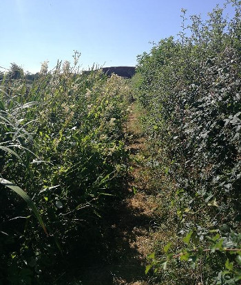
Sadly, on reaching the Oxford at Sutton Stop, I’ve returned to overgrown banks and encroaching offside vegetation. Through the high growth along this canal, the towpath seemed to be mown within an inch of its life—until the outskirts of Braunston. Kevin's photograph shows the waterway between bridges 88 and 89.
The last time I witnessed jungle conditions like this was when I escorted Jeff Whyatt, erstwhile manager of the Oxford/GU region that was, on a safari from Aynho wharf to Aynho lock. Then the excuse was a new contractor was being inducted into the machinations of CaRT Health and Safety and it was taking a while (12 weeks?!) to get them up to speed.
Dire conditions
Since then I’ve even had two CaRT staff on my boat from Fenny Compton to Marston Doles so that I could give them the boaters’ (notice the correct use of punctuation*) perspective of the dire conditions along the summit.
Previously I had been interviewed by Radio Oxford over the conditions on the South Oxford where it was so bad the navigation was not visible.
With no rainfall for weeks, the only conclusion I can draw is that Fountains [the contractors] are getting away with not doing their job and that there is a total lack of CaRT inspection along the canal to flag up this point. If the rain does fall in the coming weeks, woe betide anyone trying to walk, cycle, fish or run between Braunston and Willoughby.
Lack of towpath control
The further south along the GU/Oxford, the lack of towpath vegetation control carries on. Growth at towpath edges has led to restricted views approaching bridge holes and bends.
Two years ago, I took a couple of CaRT staff on a journey from Fenny Compton to Marston Doles, pointing out the hazards to navigation caused by lack of vision, overhanging offside vegetation and lack of a channel suitable to allow boats to pass. In the main they took notice and the following year the situation improved dramatically.
 Dangerous situation
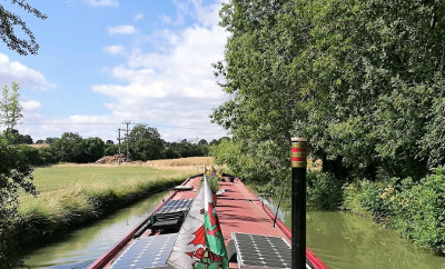
Unfortunately, they didn’t do enough and there now remains a very dangerous situation on the summit of the Oxford. The photograph below shows the approach to one of the sharp 90 degree (plus) bends, this one not far from bridge 126 at Stoneton. The steerer cannot hope to see what may be coming and the boat, already on the 'wrong' side of the channel, is in a position to be T-
boned by oncoming craft especially as there is a trend to cut corners.
Despite its new branding, CaRT clearly demonstrates its lack of commitment to the general public, who they claim are 90% of canal users (remember boaters don’t figure).
Withheld their annual fees
In an age where a mass protest makes those in authority wake up and smell the coffee, if every one of the 33,000 licensed boaters withheld their annual fees, would those in the Milton Keynes centre of the canal network office take note? Oh sorry, just had a wild dream.
* The ineptitude of the organisation to realise such a grammatical oversight shows it doesn't have the wit to manage the 2000 miles of decaying waterway network. Shame on you Richard Parry, I once thought you would make a difference; not now.
With so much of the network now shut for navigation, but otherwise open for all walkers, cyclists, fisherpersons et al, is this the true objective—close the entire system by stealth?